Friday, January 25, 2013

The author of a track in bushland is whoever forms the track.

Skill and Judgement

A formed walking track made through the bush is an artistic work in Australia, and hence subject to copyright, because the creativity, skill and judgement exercised in selecting its route makes it a sculpture or engraving, and is a work of artistic craftsmanship.

In creating a walking track, one doesn't simply follow a bearing from start to end point, but rather actively chooses a route over terrain.  The choices made by a walker are conditioned by the topography, surface area, ground cover and a desire to arrive at certain points of interest.

The formation of a bush track satisfies all of the criteria enunciated by the Federal Court in the Sensis Case (Telstra Corporation Limited v Phone Directories Company Pty Ltd [2010] FCA 44 (8 February 2010)):  the expenditure of “independent intellectual effort” involving a “creative spark” and the exercise of a requisite “skill and judgment”.

Such works could be considered Land Art, and many famous examples of such works exist.

Case:  Folly Point.

We can consider a specific case, the formation of the Folly Point track in the Budawangs.  John Evans gives an excellent account of walking the track in 2010, and includes maps, kml tracks, photos and videos.

At the end-point of Folly Point track there's a pass named Watsons Pass leading from the cliff line into a deep gorge.  The pass was named for Colin Watson, who is held to have discovered it.  Colin Watson says, in his autobiography (pp 163):
I decided to explore farther below Folly Point and to start cutting a track to this point with machetes.  Glen Wilson, Bruce Ingram and Howard Dries left on Bank Holiday, 1962, weekend and took a day exploring the best way out to Folly Point, a distance of about five miles.
We are given the date of creation, the authors' names, and the statement that they had to explore to find the "best way" for the track to be cut.  This is a creative work requiring substantial skill and judgement, which is further proven by the fact that an entirely novel and original pass was found as part of the exploration.

State Copyright Claims

The Corang topographic map sheet contains a reproduction of the Folly Point track, over a claim of copyright by the State of NSW.

I think, in view of the Sensis case, any claim to owning the copyright of Watson's track would have to fail in view of the clearly demonstrable provenance of the work.  The mere compilation of the track does not confer on the publisher of the map any copyright recognised by the law of the Commonwealth.

Tracks of Ancient Provenance

Most of the tracks in the Budawangs can be traced back through the literature to Aboriginal walking tracks, bridal paths (many of which followed the Aboriginal tracks,) roads formed by timber getters in the early 1900s (and before.)

In none of these can any authorship be asserted by the map making authority on behalf of the state.

The Cartographer's Art

While there is, no doubt, an art of cartography, and while I believe that a great deal of skill and judgement may be exercised in the recognition and recording of geomorphological features such as cliff lines and swamps, and land cover, it is certain that a map maker cannot claim authorship of all features recorded on a map they draw - even more so when the systems used to produce the map are "designed to limit originality, not provide for it" (Federal Court Judgement, above.)

When we subtract (from a topo map) contours (derived from DEM models) water features (derived from DEM and hydrological models) tracks and trails (created by someone other than the map maker) there's not a whole lot left.

Tuesday, January 15, 2013

Cliffs, what cliffs?

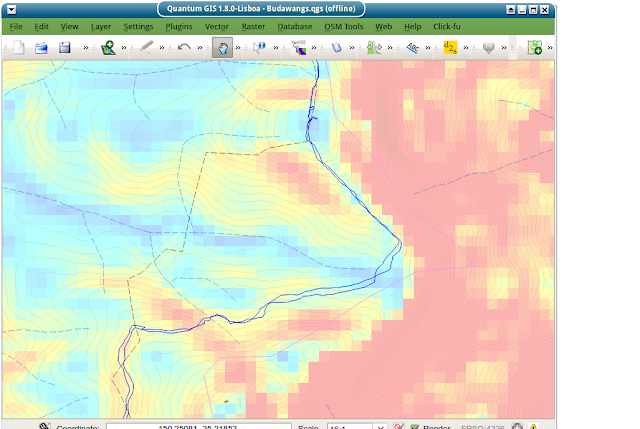
I was looking in detail at the (poorly georeferenced) sketch map overlaying the topo map.  underneath is a pseudo-coloured altitude wash:
Here's roughly the same area with red polygons for the topo's cliffs ... *way* out:

Here's a GPS track (in blue)


 Same GPS track with pseudo-coloured slope wash, derived from 1sDEM


Note that the particular slope calculation (gdaldem slope) is really chunky ... not unexpected, really, as the scan is 3m vertical res but only something like 30m horizontal res (whatever 1 arc-second is at the surface of the earth.)  Part of it, too, is the colour quantization - I'm guessing the display is only doing 8 bits of colour.

The contours are much more informative, even though they're derived from the same scan ... this is, I think, because contours can extract information from more than one data point ... they presuppose continuity which permits that.


Just for completeness' sake, here's the GPS track, the topo track and the topo cliffs overlayed on google's imagery.

Sunday, January 13, 2013

No bushwalking in fire season.

Closing tracks and whole areas of national parks is not about protecting bushwalkers from wildfire, it is only about protecting bush from bushwalkers' fires. As such, it is a short-sighted practice, based on false premises, doomed to fail in the medium- to long- term, but it does have the effect of putting off the inevitable. Short-term thinking at the political level will win every time.

The fact we haven't had a Blue Mountains bushfire this time around is mainly attributable to heavy surveillance of known arsonists, and luck. A bushwalker cooking dinner is indistinguishable from an arsonist, in the governmental model, since both have the effect of kicking off a chain reaction we are unable to control. Since arson surveillance has worked to prevent the blue mountains sparking up (and it has, make no mistake,) of course the government will extend the ban to anyone with the ability to make fire.

SITREP: NSW, all of it, is tinder-dry after an historically dry summer. The fuel load is very high as a consequence of the drought breaking a couple of years back. The National Parks and Wildlife Service [NPWS] has (for some reason I don't understand(*)) stopped preventative/mosaic burning to reduce fuel load. Canberra went up recently, Victoria went up recently. The fire service is completely focused on preventing damage to property (with consequent loss of life.) The Lib-NP coalition are only fairly recently in government - they don't want a disaster. They don't really care much about bushwalkers, they care a lot about adverse media coverage and property owners, hence any argument based on risk to bushwalkers will have no impact.

NPWS is consequently, and quite understandably, highly risk-averse. For example: NPWS fire policy for Royal NP was to 'prevent' wildfires for 15-20 years after the last major fire ... how they're going to achieve that is beyond my ken, but that was the policy last time I looked. The decision makers are operating under the delusion that they can stop the bush burning indefinitely if they can just keep flame away from it, and this is the fundamental reason they've closed the parks.

Seems to me quite likely that there's going to be a conflagration sometime soon (this summer, next summer) and that there's nothing anyone can do, now, to prevent it (or even, really, to ameliorate it.) The current light rain doesn't really put out the fires currently burning, it just means the RFS can't backburn.

It's pure luck that the weather happens to have been favourable. A pure fluke has delayed the inevitable. Sometime in the next little while we will have a week of extremely hot weather, and then an afternoon of strong winds, and there will be another series of wildfires. Property will be destroyed, people will die. The NPWS decision makers are keen that it not happen on their watch.

I could be completely wrong, but to the extent that I understand the issue: Australia's dominant flora has evolved to cause fire. For millenia aboriginal and (for centuries) historical pastoral practice was to selectively burn to keep the understories clear, and to generate feed for native and then introduced grazing animals. If I understand it correctly, it is necessary to burn selectively over cooler months to avoid conflagrations (although the art of doing this effectively has been lost.)

We, for some reason(*), have chosen not to maintain the country, and we will (as a direct consequence of this) suffer the consequences.

As far as National Parks go, I blame the Wilderness Act which militates against burning because it pretends that something called Wilderness can exist without any human interaction or intervention. It is apparent to me that this model of the bush is a damaging fantasy based on 19th century romantic notions.

----
* Actually, it might have something to do with cuts to Rural Fire Service and NPWS funding.